Abstracts
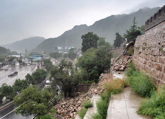
July 19, Unexpected heavy rainfall in the Changping District,Beijing caused landslides in The Juyongguan Great Wall. Fortunately, no casualty occured. When natural disasters come,what should we do? Utilise science and technology to protect historical heritage, monitor and warn disastrous weather!
Recently, several provinces suffered heavy rain and the waterlogging made huge damage on people's lives and property. Ancient buildings in the old town and the city traffic are also under a great threat. Capital Beijing faces enormous challenge of waterlogging.
At 13:50 on July 19 or so, due to the torrential rain in Beijing, A more than 30-meter-long slide appeared on the east side slope of The Great Wall South Gate Urn. After the landslide, Beijing-Tibet Expressway partly closed ,meanwhile the Ming Tombs DC Office and the Great Wall Office of Administration organized about 100 people immediately to clean the gravel section and control the spread of dangerous situation. It is known that the risk-elimination was completed at 7 pm in the 19th, the temporary closed road was open again, but the incident section was still released for single lane. On-site guarding work continued into the night. The rescue workers on the spot said the landslide surface had been broken, and if continued being exposed to the rain, the earth beneath would be washed away and the bottom would be hollowed out, causing the risk of secondary landslide. Since Beijing issued a yellow warning signal of storm in the morning of the 20th and in most areas there was still rain, torrential locally, the subsequent repair work of the Great Wall is carried out after heavy rain. Fortunately, this landslide accident caused no casualties,but the Great Wall is in need of repair.

In the face of natural disasters, ancient buildings are so fragile .Before the advent of the loss, what can we do? Whether in living or traveling everybody wants to have a safe environment, then how to avoid danger?
Human beings have a precious and rich heritage of nature and culture, but because of the age, a lot of artifacts are difficult to keep or susceptible to corrosion, and suffered worse damage coupled with the impact of modern human activity. Therefore, effective protection, recording, sorting and utilising of precious cultural relics is a very important part of heritage conservation and research and has crucial practical significance. So the adoption of advanced technology to protect heritage has become urgent problem and the emergence of laser radar technology has opened up a new path for cultural heritage protection.

China has a vast territory,complex geological and topographical condition and a variable climate, which makes the country a frequency-occurring one of geological calamity. The 2015 annual geological disaster records informed by the Ministry of Land and Resources shows that in 2015 there are a total of 8224 various geological disasters in the country, including 5616 landslides, 1801 collapses, 486 debris flows, 278 ground collapses, 27 ground fissures, 16 ground subsidences , which caused 229 deaths, 58 people missing, 138 people injured, and a direct economic loss of 2 billion 490 million yuan. Although compared with 2014, the number of geological disasters occurred, the death toll , the number of missing and direct economic losses have been reduced, the number of affected people and economic losses is still huge.The geological disaster prevention in China is still in a severe situation.

Geological disasters often accompanies with severe weather conditions, which limits the advantage of remote sensing technique. With the development of science and technology, radar remote sensing technology provides a good solution to this problem. The synthetic aperture radar emits electromagnetic wave and receives the echo by sensors and image , as electromagnetic waves can penetrate the cloud, making interference synthetic aperture radar imaging not affected by the weather. [3] Now, an all-weather, modern high-resolution microwave imaging radar --(FastGBSAR) fully polarimetric ground-based synthetic aperture radar ground appeared .FastGBSAR is a ground-based interferometric synthetic aperture radar working in KU band . The real aperture radar mode (RAR) can be used in the static monitoring of buildings and the dynamic deformation of structure ,while the synthetic aperture radar (SAR) mode in unstable natural factors monitoring and identification of artificial facilities .FastGBSAR applies to monitoring of artificial building facilities ,e.g. early warning and deformation monitoring of landslides, open pit mines, dams, railways and highway slopes, landslides and debris flows in hilly and mountainous areas , health detection and stability assessment of bridges, wind power and other high-rise buildings .FastGBSAR technology will make monitoring more efficient, in terms of accuracy and speed of acquirement, the sampling frequency, operating distance, environment adaptability, the degree of automation and labor costs ,which can reflect that it is the most professional equipment for deformation monitoring.
Technology protects the environment ,safety shapes the life.


Inferences
Luo shezhou The Applications of Laser Radar Remote Sensing in cultural heritage protection,2014.12
Monitoring Administration of Ministry of Land and Resources of the People’s Republic of China,2015【Responsibilities of the Ministry of Land and Resources】2016.04.22
Liu kongxue SAR information extraction and application in geological hazard evaluation 2012.05.